New Feature | Sun Exposure Layer

We are excited to announce our newest feature on the Spartan Forge web app: Sun Exposure. This tool is a game changer for analyzing your data and identifying trends in game movement, providing hunters, outdoor enthusiasts, and land managers with powerful insights into how sunlight interacts with the landscape. Whether you're planning your next big hunt or simply seeking to understand environmental patterns, this tool has you covered.
LOG IN NOW TO TRY SUN EXPOSURE
What is the Sun Exposure Feature?
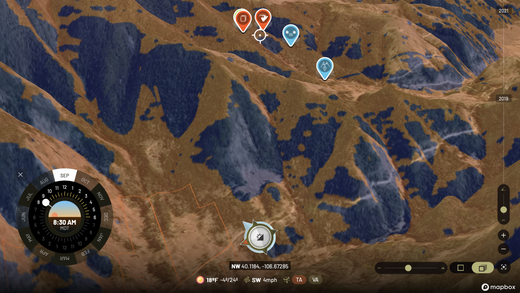
The Sun Exposure feature is a dynamic, interactive layer that allows users to visualize sunlight patterns for specific months and times of the day. Accessible via the toolbar, activating Sun Exposure opens a panel in the lower-left corner of your screen. Here, you can customize the display by selecting the desired month and time, broken down into half-hour increments. The feature also automatically adjusts for sunrise and sunset based on the month and location, ensuring accurate and location-specific data.
This tool empowers users to:
-
Identify Cooler Areas: Use Sun Exposure to locate shaded spots during hot September hunts, giving you an edge in tracking game seeking refuge from the heat.
-
Understand Thermals: Analyze how thermals behave throughout the day, helping you predict wind patterns and make more informed decisions.
-
Enhance Strategic Planning: Combine Sun Exposure data with other map layers in split-screen mode to create a comprehensive view of your hunting or land management strategy.
What is a Sun Exposure Map?
A sun exposure map is a geospatial visualization that shows how sunlight interacts with a given area over a specific period. By using advanced algorithms and topographical data, these maps calculate solar radiation levels based on factors such as:
-
Time of Year: The angle of the sun changes throughout the year, affecting the amount of sunlight different areas receive.
-
Terrain: Hills, valleys, and slopes influence how much sunlight reaches the ground.
-
Obstructions: Features like trees, buildings, and other objects create shadows and alter sunlight distribution.
Sun exposure maps are typically color-coded to illustrate variations in sunlight intensity. Areas receiving more sunlight might appear in bright yellows or reds, while shaded or less exposed regions are shown in greens or blues. This makes them a versatile tool for anyone needing detailed insights into sunlight patterns.
Why Sun Exposure Matters
Understanding sun exposure is crucial for a variety of applications:
1. Game Hunting and Wildlife Tracking
Animals, particularly elk, deer, and other game species, tend to gravitate toward areas with optimal thermal and sunlight conditions. By using the Sun Exposure tool, hunters can:
-
Pinpoint likely game hotspots, such as shaded areas on sunny days or open areas during cooler times.
-
Predict movement patterns based on sunlight and heat preferences of the game.
2. Thermal and Wind Behavior Analysis
Thermals, or air currents influenced by temperature differences, play a critical role in hunting. With Sun Exposure, you can:
-
Visualize how sunlight warms different areas, creating thermal lifts.
-
Plan hunting strategies that account for shifting wind patterns throughout the day.
3. Outdoor Recreation Planning
For hikers, campers, and land managers, knowing where sunlight falls at specific times is invaluable. Use this feature to:
-
Find ideal camping spots that remain shaded during hot afternoons.
-
Plan routes to avoid overly exposed areas during peak heat.
4. Agriculture and Land Management
Farmers and land managers can benefit by:
-
Analyzing sun exposure to optimize planting locations for crops.
-
Planning irrigation or shading solutions for water conservation.
How to Get the Most Out of the Sun Exposure Feature
To maximize the potential of Sun Exposure, here are a few tips:
-
Use Split Screen Mode: Combine Sun Exposure with other map layers like terrain, vegetation, or wind patterns to gain a comprehensive understanding of the area.
-
Experiment with Different Times and Months: Understanding how sunlight changes throughout the year can reveal seasonal trends that are critical for planning.
-
Pair with Weather Data: Sun Exposure works best when complemented by real-time weather information, such as temperature and wind conditions.
Why This Feature is a Game Changer
Sun Exposure simplifies complex sunlight analysis, making it accessible and actionable for a broad range of users. For hunters, it means better preparation and higher success rates. For land managers and outdoor enthusiasts, it provides insights that improve safety, efficiency, and environmental stewardship. By integrating this tool into your planning process, you can:
-
Save time by visualizing key sunlight trends directly on your map.
-
Make informed decisions based on precise data.
-
Gain a deeper understanding of how sunlight interacts with your environment.
Don't forget to give Sun Exposure a try during your next trip or planning session. It’s available now in the toolbar—ready to revolutionize the way you see the landscape!


